
click to see original condition
 Sixties City
click to see original condition
|
click to see original condition |
Sixties City |
click to see original condition |
|
|
 MAP MAP |
|
The offshore forts, or
towers, which interested the pirate radio stations of the
Sixties were originally World War II military facilities
built to protect the coastal sea lanes and were essentially
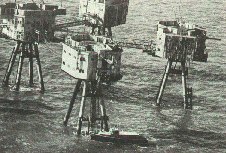
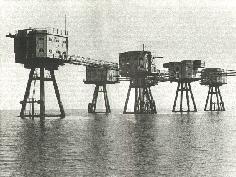
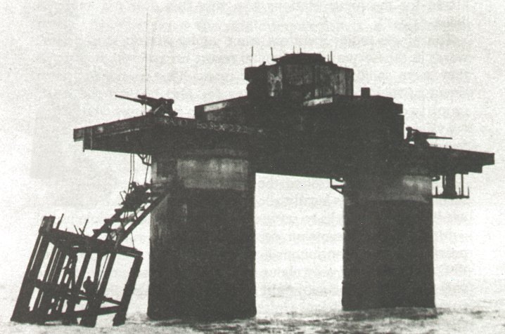
of two designs. Red Sands, Shivering Sands and Great Nore were Army constructed, originally consisting of seven separate towers, each set on four concrete legs supporting a steel structure 100ft above sea level and connected by narrow catwalks. This complex consisted of five gun towers, a searchlight tower and a main control tower. The towers were towed out on specially constructed barges, two at a time, and set into the sea bed. Red Sands was put in place between July 23rd and September 23rd 1943 at 51.28.62 North 0.59.60 East and Shivering Sands between September 18th and December 13th 1943 at 51.29.95 North 1.04.48 East. Great Nore tower had been completely uninhabitable since the mid-fifties and did not survive into the Sixties, having been demolished in 1958 as it was blocking the main approach to the Thames ports. HMF Roughs, HMF
Sunk Head, HMF Knock John
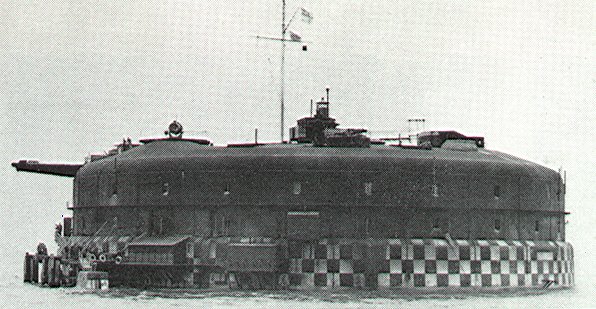
and HMF Tongue Sand, known as 'His Majesty's Forts', were built by the
Navy and originally had a complement of about 100 men who were assigned
to them before deployment. These were designed as a reinforced concrete
pontoon measuring 168 by 88 feet supporting two hollow cylindrical towers,
24 feet in diameter, which were topped by a gun deck, an upper deck and
a central tower unit which controlled radar equipment. They were constructed
in harbour and on completion were towed into position by three tugs and
then sunk,
leaving only the large diameter towers and platform showing above sea
level. They were operable within 30 minutes of 'launching'. The tower
'legs' were divided into seven floors, providing accommodation and storage
areas. There was a steel framework at one end supporting a landing jetty
and crane which was used to hoist supplies aboard. |
|
Both types were
designed to house various gun installations ( quite visible
on many pictures ) to combat the twin threats of enemy
aircraft and E-boats. The original armament consisted of two
4.5" guns mounted on the main decks, four Lewis machine guns
and two Bofors 40mm guns on the upper deck with the central
tower supporting a radar scanner dish. |
|
|
The forts were not a popular posting and were abandoned wholesale by the military at the end of the war after which ownership became a matter of opinion as they were generally considered to be situated in international waters and not subject to any particular mainland jurisdiction. In fact, the War Office seemed to be rather keen to pass responsibility for them onto other government departments having tried, unsuccessfully, to sell them off in 1963. This didn't really matter, of course, as they were doing no harm and were of no real practical use to anyone - until pirate radio came along. A third type of offshore fort was also in existence, notably Horse Sand Fort in the Solent, but did not figure significantly in pirate radio activities. By an extremely questionable interpretation of an obscure passage in the Geneva International Convention of the Sea, 1958, which was ratified in September 1964 by the British government in an Order in Council: 'The ( Thames ) estuary may be considered as a bay if the area of water within the bay exceeds that in a semi-circle drawn, with a 24 mile baseline, across the indentation in the coast' and another debatable decision which considered sandbanks visible only during unusually low tides at certain parts of the year to be part of the British mainland, all of the towers, except Roughs and Sunk Head, were declared to be inside territorial waters and therefore subject to prosecution under the Wireless and Telegraphy Act. The area of water in the bay, 683 square miles as calculated by a Ministry of Defence naval surveyor, was only 5 square miles more than that inside the theoretical semi-circle! |
|
The last military maintenance teams were withdrawn from the towers in the winter of 1958/59 and by the Sixties all the offshore towers were already in a state of considerable neglect and disrepair, offering at best only a bare minimum of facilities and were to prove impossible to supply for long periods during bad weather. This is part of a description of Shivering Sands, which was the home of RADIO CITY. The fort had lost one of its towers when a ship ran into it, killing four people: |
|
|
Also, being in open sea areas and constructed largely of metal, they were natural lightning conductors. On Red Sands, D.J. Paul Beresford of RADIO 390 was actually struck by lightning, not only surviving but managing to broadcast his usual programme only hours later! Even on good days huge build-ups of static electricity were apparently a problem and there are many recounted tales of station staff being thrown some distance after carelessly grabbing metal door handles. Minor things like that, however, didn't seem to be any deterrent to the more determined pirate radio station operators. |
|
|
The planned final destruction of
the towers commenced on 21st August 1967 when a team of 20 Royal Engineers
demolished
the upper sections of Sunk Head using 2200lbs of explosives, in front
of a specially invited audience of television and press reporters, with
a blast that could be seen both from the Radio Caroline ship and by
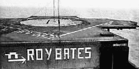
Roy Bates on Roughs tower six miles away. |
|
Later that year the Royal Navy attempted
to remove him from the structure but abandoned the attempt when they
were met with warning shots fired from the tower. Following this incident
legal action was brought against him by the government but was subsequently
dropped when the courts ruled that they had no jurisdiction outside
British territorial waters.
During early 2000 Spanish police brought action against criminals that had set up a website selling fake Sealand 'passports' which are suspected of having been used by illegal arms and drug-dealing rings. One of these fake 'passports' was also encountered by police investigating the murder of fashion mogul Gianni Versace. In June of 2000 an Anguillan-based company called HavenCo announced preliminary plans to locate its servers and satellite uplinks on the Sealand platform provided its independent status could be validated. The purpose of this is to allow companies using its servers to avoid the government scrutiny which will be made possible by laws shortly to be taken up by the U.K. and U.S.A. although HavenCo insist that it will not allow any form of illegal trading. Sealand, of course, has no laws regarding the control of data traffic. I await further developments with interest. |
